


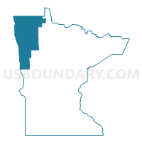
Clay, Polk, Roseau, Pennington, Marshall, Norman, Kittson & Red Lake Counties PUMA, Minnesota
About
Outline

Summary
| Unique Area Identifier | 193243 |
| Name | Clay, Polk, Roseau, Pennington, Marshall, Norman, Kittson & Red Lake Counties PUMA |
| State | Minnesota |
| Area (square miles) | 9,572.56 |
| Land Area (square miles) | 9,483.73 |
| Water Area (square miles) | 88.82 |
| % of Land Area | 99.07 |
| % of Water Area | 0.93 |
| Latitude of the Internal Point | 48.05311570 |
| Longtitude of the Internal Point | -96.31678280 |
Maps

Graphs
Select a template below for downloading or customizing gragh for Clay, Polk, Roseau, Pennington, Marshall, Norman, Kittson & Red Lake Counties PUMA, Minnesota


Neighbors
Neighoring Public Use Microdata Area (by Name) Neighboring Public Use Microdata Area on the Map
- Beltrami, Becker, Hubbard, Clearwater, Mahnomen & Lake of the Woods Counties PUMA, MN
- Cass County--Fargo City PUMA, ND
- East Central North Dakota--Jamestown City PUMA, ND
- Northeast North Dakota--Grand Forks City PUMA, ND
- West Central Minnesota PUMA, MN
Top 10 Neighboring County (by Population) Neighboring County on the Map
- Cass County, ND (149,778)
- Grand Forks County, ND (66,861)
- Clay County, MN (58,999)
- Otter Tail County, MN (57,303)
- Beltrami County, MN (44,442)
- Becker County, MN (32,504)
- Polk County, MN (31,600)
- Richland County, ND (16,321)
- Roseau County, MN (15,629)
- Pennington County, MN (13,930)
Top 10 Neighboring County Subdivision (by Population) Neighboring County Subdivision on the Map
- Fargo city, Cass County, ND (105,549)
- Grand Forks city, Grand Forks County, ND (52,838)
- Moorhead city, Clay County, MN (38,065)
- East Grand Forks city, Polk County, MN (8,601)
- Thief River Falls city, Pennington County, MN (8,573)
- Crookston city, Polk County, MN (7,891)
- Dilworth city, Clay County, MN (4,024)
- Roseau city, Roseau County, MN (2,633)
- Barnesville city, Clay County, MN (2,563)
- Lake township, Roseau County, MN (2,090)
Top 10 Neighboring Place (by Population) Neighboring Place on the Map
- Fargo city, ND (105,549)
- Grand Forks city, ND (52,838)
- Moorhead city, MN (38,065)
- East Grand Forks city, MN (8,601)
- Thief River Falls city, MN (8,573)
- Crookston city, MN (7,891)
- Dilworth city, MN (4,024)
- Roseau city, MN (2,633)
- Barnesville city, MN (2,563)
- Hawley city, MN (2,067)
Top 10 Neighboring Elementary School District (by Population) Neighboring Elementary School District on the Map
Top 10 Neighboring Unified School District (by Population) Neighboring Unified School District on the Map
- Fargo Public School District 1, ND (89,584)
- Grand Forks Public School District 1, ND (54,106)
- West Fargo Public School District 6, ND (48,867)
- Moorhead Public School District, MN (42,969)
- Thief River Falls School District, MN (13,460)
- East Grand Forks Public School District, MN (10,085)
- Crookston Public School District, MN (9,712)
- Pelican Rapids Public School District, MN (7,434)
- Roseau Public School District, MN (6,728)
- Warroad Public School District, MN (6,181)
Top 10 Neighboring State Legislative District Lower Chamber (by Population) Neighboring State Legislative District Lower Chamber on the Map
- State House District 9A, MN (42,418)
- State House District 2B, MN (39,744)
- State House District 9B, MN (39,347)
- State House District 2A, MN (37,063)
- State House District 1B, MN (36,188)
- State House District 10A, MN (35,993)
- State House District 3A, MN (35,316)
- State House District 1A, MN (35,146)
- State House District 27, ND (26,013)
- State House District 22, ND (20,531)
Top 10 Neighboring State Legislative District Upper Chamber (by Population) Neighboring State Legislative District Upper Chamber on the Map
- State Senate District 9, MN (81,765)
- State Senate District 2, MN (76,807)
- State Senate District 3, MN (73,721)
- State Senate District 10, MN (73,591)
- State Senate District 1, MN (71,334)
- State Senate District 27, ND (26,013)
- State Senate District 22, ND (20,531)
- State Senate District 46, ND (15,488)
- State Senate District 17, ND (14,995)
- State Senate District 45, ND (13,993)
Top 10 Neighboring 111th Congressional District (by Population) Neighboring 111th Congressional District on the Map
Top 10 Neighboring Census Tract (by Population) Neighboring Census Tract on the Map
- Census Tract 405, Cass County, ND (23,686)
- Census Tract 301.04, Clay County, MN (6,882)
- Census Tract 301.03, Clay County, MN (6,853)
- Census Tract 9400.01, Beltrami County, MN (5,885)
- Census Tract 117, Grand Forks County, ND (5,882)
- Census Tract 206, Polk County, MN (5,693)
- Census Tract 302.01, Clay County, MN (5,631)
- Census Tract 205, Clay County, MN (5,626)
- Census Tract 201, Clay County, MN (5,459)
- Census Tract 301.02, Clay County, MN (5,419)
Top 10 Neighboring 5-Digit ZIP Code Tabulation Area (by Population) Neighboring 5-Digit ZIP Code Tabulation Area on the Map
- 58103, ND (47,302)
- 56560, MN (40,766)
- 58201, ND (34,880)
- 58102, ND (29,850)
- 58104, ND (28,322)
- 58203, ND (18,229)
- 56701, MN (12,690)
- 56721, MN (10,096)
- 56716, MN (9,416)
- 56751, MN (5,575)